Oakridge Estates - Newbury Park
Where sunset arrives a bit early
July 2006 Newsletter Puzzle Solution
Puzzle:
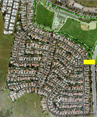
You've got a new job—to drive Oakridge Estates and toss the Oakridge Gazette into every driveway from your bicycle. You’re paid $20/mile in quarter-mile increments. You start and end at the corner of Cayo Grande Court and Calle Clara Vista (see lower left corner of the yellow rectangle below). How much do you make?
(a) $45, (b) $55, (c) $65, (d) $75?
 |
| Oakridge Gazette Paper Route |
Answer:
(c) $65. The route is 3.25 miles long.
For the curious, here's how I calculated this distance.
I went to the Online Mapping page of the Thousand Oaks website,
which has changed since 2006, so the information that follows is no longer
available. Today, however, online mapping may be found at this web address:
https://www.toaks.org/about-us/about-thousand-oaks/online-mapping.
Click on ![]() and when the following
window appears, enter your street address in the
empty box and press Enter:
and when the following
window appears, enter your street address in the
empty box and press Enter:
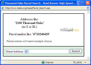
If the address is valid, a window with the address and parcel number will appear. Click on the address. A map showing the parcel location will appear.
To enhance the view, do the following:
- Maximize the viewing area by pressing F11 (equivalent to View —> Full Screen) in your browser window.
- In the left panel:
- Uncheck the Assessor's Parcels box
- Uncheck the Centerlines and Centerline Labels boxes (to remove the street names)
- Check the 2005 Air Photo—March 15 box (near the bottom of the panel)
- Shrink the size of the left panel by clicking on the border
between the panel and the map and when the resize symbol
 appears as a mouse
pointer, drag it left as desired to expose more of the map area.
Note the symbols at the top of the page:
![]()
You will ordinarily use only the four that are underlined above in red. Click on one to select it and activate the corresponding function:
- The arrow (ToolTip=Select) selects one or more parcels but is inactive when Assessor's Parcels is deselected.
- The hand (ToolTip=Pan) moves the map. When selected, click and drag the map to view a new area.
- The zoom in (ToolTip=Zoom) symbol zooms in and recenters the map where clicked.
- The zoom out (ToolTip=Zoom Out) symbol zooms out and recenters the map where clicked.
A host of other functions are activated by right-clicking the mouse. Here's how you might measure the distance of the Oakridge Gazette route. You can use the same technique to measure accurate distances (even to the nearest fraction of a foot depending on the zoom level) anywhere in the area the map covers.
Measuring the Distance of the Paper Route
- Center the Oakridge map on the screen, using the zoom and pan tools as needed.
- Now display the entire map of Oakridge on the screen, making it as large
as possible, yet with every street displayed. To do this, use the pan and
zoom tools along with the zoom to scale feature. Right
click the mouse and select Zoom —> Scale...:
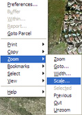
- In the window that appears, enter a new Zoom scale. For
example, to zoom in from 1:7,866 to 1:5,200, you would enter:

- Once the map is in an optimal size and location, you invoke
the measure distance feature. Right click and select View —>
Distance:
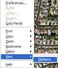
- Click on a starting point. To solve the puzzle, click
at the corner of Calle Clara Vista and Cayo Grande Court. From that point,
click on the route you wish to take. Each time you click, a straight line
from the previous click is drawn and the distance measured. For example,
to measure the distance around a baseball diamond, you would click five
times (home, first, second, third, home). After each click, a yellow box
appears showing two values: the length of the current segment and the total
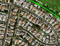
distance. For example, after measuring about 7 segments along Cayo Grande,
past Las Colinas, you have traversed 1,144 ft including 142 ft into the
current segment:
 plus
plus 
- To terminate the measuring, press the Esc key. If you
measure the entire route, you should have traveled about 3.25 miles:

Measuring Note
Your calculated distance will vary from someone else's, because everyone will measure slightly differently. For the distance above, ride your "bike" only on the streets, stay as close as possible to the center of every street, and go to the very end of every cul-de-sac.
Still, if you ask 10 people to measure the distance, you'll likely get 10 answers. The answer of 3.25 miles is not necessarily the exact answer. This is just a puzzle designed to engage you and perhaps expose you to a cool tool.
Although there is more than one route though the tract, there is no one best route. The tract layout requires that you backtrack on every cul-de-sac, on the segment of Las Colinas between Calle Buena Vista and Cayo Grande Court, and on the segment of Lesser Drive between the end of Calle Alta Vista and Calle Mazatlán.
You may come up with a distance under 3.25 miles, perhaps as low as 3.00 miles. However, the person who has hired you is very generous, and is willing to pay you based upon the higher estimate, because he wants to retain you. You may be delivering the Gazette today, but tomorrow you'll be writing stories for it, and perhaps someday you'll be managing editor!